The National Mapping and Resource Information Authority (NAMRIA), as of last count, listed the Philippines as having more than 7,500 islands. Some of our islands are now disputed territory. To combat China’s “historic” claim to these islands, Supreme Court Senior Associate Justice Antonio Carpio has been using ancient maps of the Philippines, including the Selden Map of China.
The Selden Map is named after London lawyer John Selden, who died in 1654 and whose heirs gifted the map to the Bodleian Library, Oxford University in 1659. The map was used and reused by scholars throughout the centuries, but the map’s significance was not highlighted until historian Robert Batchelor used it in 2008.
Since then, the map has been painstakingly cleaned and restored, digitally photographed, and was subject of an academic colloquium at Oxford in 2011 and an international symposium on “New Research into the Maritime Trades, Seafaring and Underwater Archaeology of the Ming Dynasty” at the Hong Kong Maritime Museum on June 7-8, 2014. View all the portions of the map in high definition image at http://seldenmap.bodleian.ox.ac.uk/
If you are in Hong Kong, visit the Hong Kong Maritime Museum at the Central Ferry Pier No. 8, Man Kwong St., Central and view a huge interactive digital version of the map.
The discovery
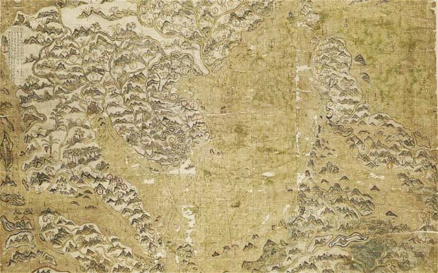
The Selden Map throws light on the significance and importance of the Philippines in the maritime silk route of China.
Robert Batchelor, professor of the Department of History at Georgia Southern University, was doing research on Sino-British trade at the Bodleian Library when he saw the Selden Map and recognized its unique features.
It is the first Chinese map to depict China as part of a greater East and Southeast Asia, and not the center of the known world. It is also the earliest Chinese map that showed both shipping routes with compass bearings from the port of Quanzhou across the entire region.
The map vividly illustrates the landscape of Hokkien merchants’ commercial activities in historical maritime Asia. The researchers could not make sense of many of the places in the Philippines found in the map. Through research connections, Batchelor sought the help of Kaisa Para Sa Kaunlaran and Bahay Tsinoy Museum in identifying the places. We manipulated the map digitally to enhance the Chinese words to make them readable, and then began matching these places with other ancient maps and Chinese records.
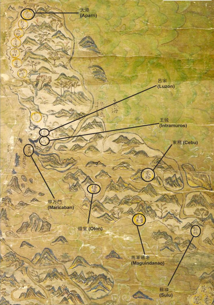
Even at first glance, Kaisa researchers immediately recognized that the place names are in Hokkien, and that these names were known only to Chinese merchants in the Philippines. Very distinct among these place names are the northernmost tip of Luzon labeled as Tua-Kang (Da Gang 大港). Only the Chinese in the Philippines would know that Tua-Kang refers to Aparri; and Ong-Snia (王城) refers to Intramuros.
Jiao Tianlong, chief curator of the Hong Kong Maritime Museum, notes that the Selden Map “stands out as an anomaly among all the known Ming dynasty maps.”
Compared to other maps where China is at the center and other countries are squeezed in all other directions with no concern for proportion, the Selden Map focuses on the southern Chinese coastline in its center, with Southeast Asian countries in relatively accurate positions.
Batchelor later published his book, The Selden Map and the Making of a Global City, 1549-1689 (University of Chicago Press: 2014).
Philippine places identified
The Philippines stands out in the entire Southeast Asia portion with the most number of names (a total of 16) marked in the map. The islands were depicted much more accurately than in other maps of the period.
This led to Batchelor’s argument that the map may have been commissioned by Li Dan, a renowned pirate from Luzon.
Scholars mostly agree that the maker is from Fujian because the Chinese characters on the map are mostly to be read in the southern Chinese dialect rather than in Mandarin. Evidence on the map itself strongly concurs with Batchelor’s view that it was made by a Chinese in the Philippines. Our research included the following Chinese records:
- 東西洋考 Dong Xi Yang Kao (East West Ocean Examination 1617 East West Ocean)
- 中國古籍中有關菲律濱資料彙編 Zhongguo Guji Zhong You Guan Feilubin Ziliao Caobian (A catalogue of materials about the Philippines in Ancient Chinese records1980 Ancient Records)
- 順風相送 Sun Feng Xiang Song (Voyage on Favorable or Tail Winds, ca 1403/ 17th Century Favorable Winds
- 指南正法 Zhi Nan Zheng Fa (Compass Directions ca 1685 Compass Directions)
The first seven names on northwestern Luzon are the same as the place names appearing in East West Ocean. All Chinese characters appearing below are translated into Hokkien.
- 大港 Tua-Kang is Aparri.
- 射崑美 Sia Khun Bee is identified in Ancient Records as Sanchez Mira, Cagayan province.
- 月投門 Ge Tho Meng. In Ancient Records, it refers to San Fernando, La Union in Western Luzon. It is also mentioned in Favorable Winds and Compass Directions.
- 香港 Hiong Kang. This is a strange place name because it is the same characters for Hong Kong. But Hong Kong of China was not yet known in the early 17th century. The characters literally mean fragrant harbor, and based on its geographical position, this could most possibly be the historic city of Vigan, which appears in East West Ocean as 美岸 Bi-Gan or beautiful shore; in Favorable Winds as 密雁 Bit-ngan, meaning many swallows; and in Compass Directions as 密岸 Bit-Gan, honeycombed shores or a place with many shorelines. Ilocos indeed has a long shoreline and was a favorite source of birds (swallows) nests in early maritime trade. It was already a favored town with historic stone churches during early Spanish rule.
- 南旺 Lam-Ong. Ancient Records places this as Langangan in Northern Luzon but based on the position, this could more probably be Namoah, west of Aparri.
From Philippine history, this place already had a Catholic church built by the Spanish colonial government in 1570, so it must have been a center of population and activity during early Spanish occupation. - 台牛坑 Thay Gu Khang literally means cattle slaughter pit. Ancient Records indicates it could be an ox slaughterhouse in Aparri or in Vigan. But from its position, it could also refer to Rancho, south of Vigan. Rancho in Spanish means a ranch (possibly the cattle ranch used in the map).
- 玳瑁 Dai Mao means turtle shell which commonly refers to Lingayen.
These seven names are solid clues revealing the map maker’s familiarity with the Philippines.
Numbers 1 and 7 are commonly depicted in other Chinese maps.
We spent much time and effort tracing the other locations.
Some of them, like Thay Gu Kang, is a small location and would most probably have been included in the map only because it is important to the map maker. As well, the characters used for the location is not really a place name but the function of the place as cattle slaughter pit.
Numbers 5 and 6 were the subjects of the January 2016 road trip taken by researchers from Kaisa. Where is Lam-ong? Where is Thay Gu Khang? What happened in those two places? There must have been something significant in the areas to warrant their inclusion on the map! - The cluster of characters 化人蕃在此港往來呂宋 means “Spaniards are in this harbor. From this port back and forth to Luzon.” To its right is 東海 (Eastern Sea). This port where Spaniards travel back and forth refers to the San Bernardino Strait in Albay. It is very significant here because this is the navigation route of the galleon trade. From Manila Bay, the galleon went south then up again to Bicol through San Bernardino Strait in Albay, then up and out to the Pacific Ocean going to Acapulco. This is the second significant clue that the map could have been made by a Chinese living in the Philippines who was familiar with the navigation routes used by the galleons. The use of the term 化人 (Hua-lang) is also very interesting. A simple Google translate will yield “of people” as a definition of 化人, while 化 means transform, change, convert. Some old Chinese speculate that the earlier traders used the term to refer to the Spaniards as people who love to tell tall tales (化仙). The term is a unique one used only by the Chinese in the Philippines to refer to the Spaniards. This location is also not often mentioned in colonial history books or in other Chinese maps reflecting the Philippines because most would not realize its significance in the Manila-Acapulco galleon trade. Given that there is a significant characterization to the location, it must have been important to the map maker. Also note that this section refers to the sea, thus it might be an important seafaring instruction for other Chinese merchants in the country at that time.
On the other hand, on the south side of the Philippine location is Wan Lao Gao (referring to Moluccas), where the words “Hua Lang (Spaniards) reside and Ang Meng (Red Hair referring to Portuguese) reside” appear. This is also connected to the Philippines. The Spaniards got Ternate in the Moluccas from the Portuguese in 1606 and gave it up only in 1663. In his article, Zhou Yunzhong of Xiamen University History Department points out: “The Spaniards and the Dutch fought over Ternate between 1610 to 1644.” In 1609, the Spaniards and the Dutch ceased fighting, and as cited in East West Ocean, divided the area into half. This fact is a good basis to date the Selden Map. - 頭巾礁 Turban Reef. Since the characters are written in the vicinity of the sea and could refer to a reef or shoal shaped like a head scarf or turban, it could refer to the mountain at the southernmost tip of Zambales around which maritime routes travel.
- 口鼎安. This place is not found in ancient documents but from its geography, the nearest it could refer to is what appeared in East West Ocean and Compass Directions as the Inverted Ting mountain. In Ancient Records, the inverted mountain referred to Bataan Mountain. Scholars believe it could be the Natih Mountain in Bataan because it does look like an inverted Ting vessel 鼎.
Compass Directions even mentioned a fake inverted Ting Mountain, which could refer to Mariveles Mountain beside the Natih Mountain. The Bataan Mountain is in the west of Luzon and faces Manila Bay. From the north going south toward Manila Bay, the two tall mountains seen are Natih and Mariveles mountains. - 呂宋 (王城) Luzon, Intramuros. This refers to Manila which, as early as 1372 (5th year of Emperor Hong Wu’s reign), already had a tribute mission to China. The construction of Intramuros began in 1590, thus narrowing down the date of the map’s making.
- 甲万門 Ka-Ban Meng. Ancient Records indicates that it is Maricaban Island in Batangas. During the 2014 symposium, Batchelor identified it as Ten Thousand Shell Gate (literal translation of the characters) at the Mindoro Strait or Apo Reef. This is our third clue to the maker of the map.
Maricaban is a very small town along the way from Batangas to Mindoro. We randomly asked a handful of Batangueños if they knew where Maricaban is, and all answered no. The town is 33.07 square km with 2010 population count of 16,870. If it is small now, it was even smaller then. There was no commercial value or any significant trading in the area during the Spanish period. Why then is Maricaban indicated in the map?
Even in contemporary times, only Philippine historians would realize its significance. This is the location where Pan Ho Wu instigated a mutiny in 1593 while enroute to a military expedition to the Moluccas. In that uprising, Pan and other mutineers killed Governor Gomez Perez Dasmariñas. His death was subsequently “avenged” by his son Luis Perez Dasmariñas in 1603 when 22,000 Chinese in the Parian in Manila were massacred. The maker must have been aware of these incidences. - 福堂 Ogtong. This name is not just a small municipality called Oton, west of Iloilo City in the island of Panay, whose old name is Ogtong. This is our fourth clue regarding the maker’s identity. The Mandarin pronunciation is Fu Tang. In other maps, the characters used are 惡黨 É thang. East West Ocean uses 屋堂 wu thang and 屋同 wu thong. All sound alike in Hokkien: Hoktong or Oktong. (Read Tulay, March 7, 2000 issue.)
- Cebu is 束務. Suwu in Mandarin and Sokbu in Hokkien came from the Cebuano word sugbu, literally meaning waves. Contemporary Tsinoys continue to use Sokbu, staying true to the original Cebuano term.
Cebu is quite well known in early Chinese documents. The Ming Annals, East West Ocean, Qing Dynasty Compendium, Compass Directions and many other documents used different characters to refer to Cebu, but all retain the Hokkien phonetics e.g. 朔霧, 翔霧, 速巫, 西武, 施褒. - 馬軍礁荖 Maguindanao.
- 蘇祿 So-lok. Both Maguindanao and Sulu are common in Chinese history books and other maps. Maguindanao is a province in Mindanao. Like Cebu, the place is mentioned in many records like the Ming Dynastic Annals, Compass Directions, East West Ocean and others but again, using different characters – 網巾礁老, 魍根礁老, 網巾礁荖, 網巾礁腦. Sulu, on the other hand, has been extensively mentioned in the Ming Annals and other ancient Chinese records.
Some of the Philippine place names in the Selden Map are similar to East West Ocean, Favorable Winds and Ancient Records (which is just a compilation of other ancient records). However, not all the places in these three maps are included in the Selden Map. Some names appear in one or two books but do not appear in others. Hence, we cannot conclude that the Selden Map was based on any of these books.
The map manufacturer or else the person who caused the manufacture or preparation of the Selden Map must be very familiar with the Philippines. Bigger areas like Lubang and Mamburao were not included in the map but the more obscure Maricaban was included. This bolsters the conclusion that the map manufacturer is not just familiar with the place names but also with Philippine history. (Condensed and revised from an academic paper published in the Journal of History, 2015). — First published in Tulay Fortnightly, Chinese-Filipino Digest 28, no. 21 (April 5-18, 2016): 13-15.


