A team of researchers from Kaisa Para Sa Kaunlaran headed to Cagayan Valley and Ilocos in January 2016 to find out more about locations No. 5 Lam-Ong and No. 6 Thay Gu Khang. Initial research was conducted by Conor Lim Dunham at the National Library, National Archives, University of Sto. Tomas archives and the Archdiocesan Archives of Manila.
The trip north was more of a search (or maybe a treasure hunt) than research.
Lam-Ong (南旺)
With the only clue to this location being a Catholic church in 1570, this was the starting point of the research. Internet research did not reveal anything. Dunham’s initial archival research revealed churches in the Ylocos and Cagayan regions dating from the 1590s onwards, but none in the 1570s.
A conversation with Dr. Jimmy Soria, historian based in University of Northern Philippines-Vigan, gave a new direction. During the conversation, I gave him all the possible permutations of the Chinese characters for No. 5 南旺 Nan-Wang (Mandarin), Nam-Ong or Lam-Ong (Hokkien). Soria immediately connected Nam-Ong with Namuac, Sanchez Mira, Cagayan Valley.
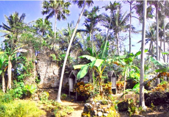
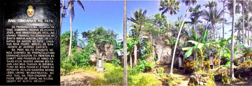
With this new information, an easy Internet search with keywords “Namuac old church” revealed “Nagsimbaanan,” the ruins of an old church erected in 1595. The National Historical Institute (now Commission) inscribed an historical marker at the ruins in the 1990s.
During the search, the main objective was to solidify theories regarding places we have found. Could Namuac be Nam-Ong? Evidence found at the site strengthens this theory:
•There was a church merely 30 years after the Spanish settled in the country;
•The church was called Simbahanng Pata. Pata was the first village in Cagayan that received Christianity;
•The church was situated right beside the Pata River;
•The path of the wide river led directly into the ocean, with the Pata Lighthouse in Claveria standing watch.
Because other parts of the map strongly indicate inclusion of trade routes, we can extrapolate that majority of the map’s locations were included because of healthy trading activities in the area. Unless proven otherwise, the evidence heavily tips the scales toward establishing that Nam-Ong is Namuac.
Thay Gu Khang (台牛坑)
Our initial theory is that this might be Rancho in Santa, Ilocos Sur. However, while in Namuac, we chanced upon a Barangay Kamestizoan. With our other research interests about all things Chinese in the Philippines, we were curious about the location and sought out the barangay captain to inquire about the barangay’s history.
Barangay Kamestizoan doesn’t seem to have anything to do with the Chinese in the Philippines. The barangay captain claims the name was derived from mestizo/mixed-breed horses in the area. However, he did point us to our next research interest – thay gu khang or cattle slaughter pit.
He instructed us to go to Barangay Pagpartian in Vigan. The barangay was established because of the common trade in the area, pagpartian, the Ilokano word for slaughtering. Currently, a cement building painted pale pink stands as the modern slaughterhouse. The slaughterhouse cooperative donated a portion of its property for a small barangay hall and gym-type assembly area whose walls depict different trades that dominated Vigan’s economy, including weaving and farming and cattle slaughtering, where herds of livestock were brought to this house to be killed.
Outside the slaughterhouse is a small tributary, on whose banks stand tableaus of two main trades in the area – slaughtering and weaving. Could this river have been used for trading as well? Having had no time to follow the river through to a bigger body of water, this evidence is not yet conclusive.
The team next headed to Rancho, Santa, Ilocos Sur where we interviewed three elders in the community. They claimed that the name Rancho has nothing to do with cattle or slaughtering. What is clear to all three men was that even before the area came to be called Rancho, it was a very active trading port. A map of the area revealed that the small islet of Rancho juts out from the main island of Ilocos Sur. North and south of the islet is already the West Philippine Sea. Those from Northern Ilocos, Aparri and all the way northeast from Tuguegarao and those from La Union (Ilocos Sur up to 1850) and Pangasinan who wanted to trade with the main island of Ilocos Sur purportedly passed through Rancho, after which other middlemen would ferry the goods across a very small tributary into the main island (approximately 500 meters to cross).
Thus, the name was derived from a verb – nag-rancho – meaning “went off to the small islet to find a job.” The elders’ stories made our theory about Thay Gu Khang fizzle out.
Next steps
The search continues. With information found about Nam-Ong, we could continue gathering evidence to further strengthen the theory that this is Namuac. Interviews with Ilocos and Cagayan historians are crucial at this point as they will point us in new directions and give us new clues to follow. Another intriguing search is about No. 3 Ge Tho Meng, which other ancient Chinese records say is in San Fernando, La Union. But is it possible that it refers to the Bantay Abot Cave in Pagudpud, Ilocos? This is a subject for future sleuthing. (With Conor Lim Dunham) — First published in Tulay Fortnightly, Chinese-Filipino Digest 28, no. 21 (April 5-18, 2016): 15.


